

Exploration Report for Muluncay Epithermal Gold Project, El Oro, Ecuador – Trilliant Exploration Corporation and Minera Del Pacifico, S.A.
Summary
This report, prepared by consulting geologist D. Bain for Minera Del Pacifico, S.A., evaluates the gold exploration potential of the Muluncay Epithermal Gold Project in southern Ecuador. It reviews the area's mining history, geology, and current exploration results, estimating significant gold resources in the concession. The report highlights the potential for further resource expansion with modern mining methods and additional exploration. The document is informational and does not create binding obligations between the parties.
EX-10.4 5 exhibit_10-4.htm REPORT ON EXPLORATION POTENTIAL exhibit_10-4.htm


Trilliant Exploration Corporation 10-K
Exhibit 10.4
REPORT ON EXPLORATION POTENTIAL
MULUNCAY EPITHERMAL GOLD PROJECT
PORTOVELO-ZARUMA-AYAPAMBA AREA
PROVINCE OF EL ORO, ECUADOR
Latitude 3° 36' 30” South, Longitude 79° 40' West
Written For: Minera Del Pacifico, S.A.
| Prepared By: | |
| D. Bain, B.Sc., P.Geo. | 49 Midale Crescent |
| Consulting Geologist | London, Ontario, |
| DUNCAN BAIN CONSULTING LTD. | Canada N5X 3C2 |
| E-mail: ***@*** | November 30, 2006 |
1
Summary
The Portovelo-Zaruma-Ayapamba district of southern Ecuador has been mined for gold and silver for centuries. The Incas were already extracting gold and silver in the area prior to the arrival of the Spanish conquistadors in 1549. For 450 years exploitation of the Zaruma and Portovelo gold mines has continued. Modern exploration, development and mining methods were applied with the arrival of SADCO in the late 1800s. Since 1905, the earliest available mining records, SADCO mining activities have produced in excess of 4.5 million oz. (144 million grams) of gold, when the cut-off grade for ore was 14.5 g/T gold. SADCO left in 1950. Only local mining continued for the next 40 years. Starting in the early 1990s, TVX and IAMGOLD have acquired and explored much of the district. In November 2006 Minera Nevada acquired a 100% interest in the Muluncay Project. It is centred at Latitude 03º36´30” South and Longitude 79º 40’ West, a distance of 175 kilometres south and 60 kilometres southeast of the major Pacific port cities of Guayaquil and Machala, respectively. The MuluncayProject lies approximately 100 km west of the Aurelian gold district and 120 km south of IAMGOLD’s multi-million ounce Quimsacocha deposit. IAMGOLD hold a series of concession surrounding the Muluncayconcession. These three gold districts are part of a regional epithermal mineralizing system which covers the southern half of Ecuador. The local population is experienced in the recognition and mining of narrow vein gold deposits, making them a valuable asset for future exploration, development and production throughout the entire region.
Triassic age Tahuin Series gneisses, schists and amphibolites, overlain byCapiro Formation mica schists, phyllites and quartzites form the basement rocks of the region. This basement is unconformably overlain by Celica Formation massive andesitic lavas and tuffs. The Celica Formation is intruded by small Lower Cretaceous age diorite/granodiorite plutons. This entire mass has been interpreted as a continental volcanic arc. These units are unconformably overlain by Oligocene Saraguro Formation felsic volcanic lavas and pyroclastics, and by later Miocene age Chincillo Formation (Pisayambo Formation) rhyolite flows and pyroclastics. There are two major regional faults, the Pinãs Fault and the Puente Busa –Palestina Fault, which have produced three tectonic blocks with down-dropped sides to the SW. Celica Formation mafic to intermediate volcanics lie between these two faults. Within the Celica Formation is the Portovelo Series andesitic lavas. Two hydrothermally altered intermediate composition volcanic series and their subvolcanic feeder systems unconformably overlie the Celica Formation. They are composed of intermediate pyroclastics and breccias, crosscut by younger rhyolite stocks, dykes and sills.
Significant second order structures include NW, NE and N-S trending high-angle faults. The N-S trending veins, dipping generally 70o to 90o NE, are the dominant structures for hosting gold, silver, lead, zinc and copper mineralization. Propylitic, argillic, silicic and sericitic alteration form concentric district-size zones. These represent a Miocene collapse caldera. Supergene enrichment of gold mineralization is recognized. Silicification represents the core of this alteration “aureole”. The deposits are classified as adularia-sericite low- to intermediate sulphidation epithermal gold system.
Regionally these mineralized veins extend horizontally for at least 15 km (the Portovelo-Zaruma-Ayapamba region), and have known depths of at least 1500 m. Past-producing veins in the district range from 60 cm to 8 m, with an average width of 1.3 m. “Stringers” and narrow veins, as well as silicified wallrock, are virtually untested for their gold potential. As is typical in a standard epithermal gold system, there are some zones of “bonanza-type” high-grade gold mineralization (locally termed “clavos”) in the 30 to 200 g/tonne range. Veins within the Muluncay concession include a minimum of 2 major veins. Unexplored and undeveloped veins are also present. Structures are oriented NNW.
Current exploration by Minera Nevada involved a site visit by the author to the district and to a series of mine workings within the Muluncay concession. Within the concession several samples of vein material were taken by the author from the Jena and Cristina veins, which are strong and persist through the entire concession over a known depth of 200 m and a strike length of 1500 m. Gold values from these samples range up to 10.40 g/T.
2
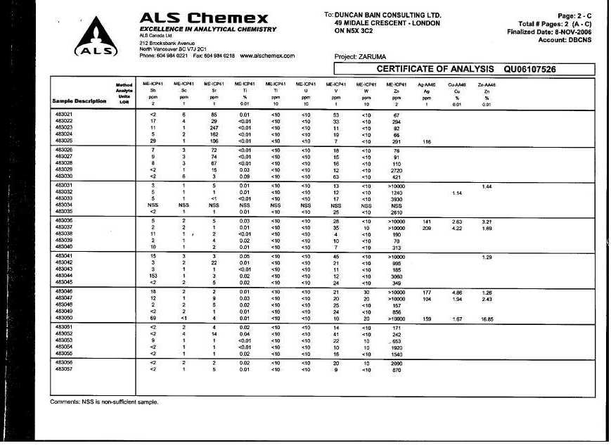
Numerous samples taken by the author in other workings within the concession show values of up to 58.6 g/T gold, up to 209 g/T silver, up to 4.86% copper and up to 16.85% zinc.
SADCO operated mines in the Zaruma-Portovelo-Ayapamba district for 46 years. During this time approximately 3.6 million ounces of gold and 12 million ounces of silver were produced. Production rates at the Grand Mine, the major producer in the district, are estimated up to a maximum of 200,000 tonnes per year, and gold grades were approximately 20-30 g/T. Significant quantities of silver, lead and zinc were also produced. SADCO operated its mines during the years when the price of gold was US$20-$35/ounce. Despite a commodity price low by today’s standards the company was profitable because of the high grades of ore available for mining.
The old SADCO operations, scattered throughout the district, generally (with the exception of the Grand Mine) only extended to a depth of approximately 200m below surface. The Grand Mine contains a gold-mineralized zone which extended to a depth of at least 660 m below surface. It was collared at an elevation 700 m below mine workings in the Muluncay concession area. This indicates that there is significant additional potential at depth of up to 1500 m for most of the concession in the district, including those veins contained within the Muluncay concession. A preliminary estimate of the resource is made by the author on the Muluncay Concession, from the two currently active veins (Jena and Cristina) with an estimated strike length of 1 km, an average width of 1.0 m and an average depth of 1000 m. Using the SADCO cut-off grade of 14.6 g/T as the average grade below current workings, this would produce an estimated tonnage of 400,000 T for each vein, or a total current resource of 800,000 T, for a total of 11,680,000 g (365,000 oz) gold. Should additional veins be found during exploration (known but not presently developed) then that tonnage estimate would increase significantly. Secondary veins, stringers, breccia and disseminated mineralization in the wallrocks have never been exploited, or even properly assessed. It is the author’s opinion that with improved, more economic mining and milling methods this resource can be taken advantage of, so that it is probable that a resource of greater than 1.6 million tonnes, with a somewhat lower grade in the order of 12 g/T (due to dilution by secondary veins and disseminations) could produce 19,200,000 g (600,000 oz) Au. No estimate of the value derived from silver or sulphide concentrate has been made, but it would add a significant amount to the value of this resource. The history of the Zaruma mining operations indicates that there is a significant opportunity to apply modern mining methods to a major resource which has had only limited exploitation in the past.
Near-term exploration should consist of the surface mapping and prospecting. Stream sediment sampling and lithogeochemical sampling should be carried out to check for sulphide content, halo effects, alteration patterns and pathfinder elements. Airphoto/satellite imagery should be examined to outline structures. All current or past underground workings should be mapped, surveyed and sampled to develop an idea of size and grade of ore blocks. Sampling should include not only vein material but wallrock to at least a metre on either side of each vein sample. Surface and underground samples should be taken approximately every 3 m along the vein. Analysis of all samples would be for gold by Fire Assay and other elements by ICP-MS. This Phase 1 program is estimated to cost $107,000.00 USD.
Using the underground sampling data an underground diamond drill program would be conducted. This work would produce a more detailed estimate of grade and tonnage for the current mine workings and for the concession. Estimated cost of this Phase 2 program is approximately $178,000.00 USD. Further work is dependent on the results of this program.
3
INTRODUCTION
The Zaruma-Portovelo-Ayapamba district of southern Ecuador has been a prolific producer of both gold and silver for over 450 years. No records of mine production exist for the first 300 years, but since 1905, over a period of only 50 years, mining activities have produced in excess of 4.5 million ounces of gold, when the cut-off grade for ore was 14.6 g/T gold. The district, an area of 150 km2, contains at least 15 major veins. Artesanal mining has continued to the present but lack of funding has prevented the use of modern exploration and mining methods to significantly increase reserves and maintain historical high grades, both along strike of these structures and to depth. Strike length of major veins can range up to 1 kilometre. Depth potential can range up to 1500 m where current mining has exploited only the first 200 m below surface.
This report has been prepared at the request of Minera Nevada S.A. and is intended to document the potential of the Muluncay concession for hosting one or more gold-silver-lead-zinc-copper deposits of sufficient grade and tonnage to be economically viable.
TERMS OF REFERENCE
The writer has been requested by Minera Nevada S.A. to make a site visit to the Muluncay Gold Project and to make a preliminary assessment of the Project for hosting sufficient quantities ofvarious mineral commodities to allow those commodities to be mined and processed at a profit.
For the purpose of this Technical Report the author, Duncan J. Bain, B.Sc.(Geology), P.Geo. is an
4
independent Qualified Person in accordance with National Instrument 43-101 and as defined in the CIM Standards on Mineral Resources and Reserves.
Grade and tonnage numbers are reported by various authors in a variety of forms, some of which include ounces per ton or % per ton. Distance measurements are often reported in feet. Wherever possible these numbers have been converted to metric equivalents, such as grams per tonne or % per tonne, and metres or centimetres, with the original values inserted to show the conversion.
This report is to be submitted to regulatory bodies including the British Colombia Securities Commission and is to be used by the Company to raise funds for further exploration on the Project.
RELIANCE ON OTHER EXPERTS
The author, Mr. Duncan J. Bain, P.Geo., visited the Portovelo-Zaruma district, including the Muluncay Project, from June 26 to July 3, 2006. The author also visited the district and was on the Muluncay Property on September 2 to 10, 2006. He was joined by Mr. Al Beaton, P.Eng., Mining Engineer and Mr. J.Ed Dhonau, a representative of Minera Del Paciofico, S.A. These site visits included both underground and surface observations of exploration, development and mining activities both within the district and on several of the mine workings located within the Muluncay concession. Detailed mapping and sampling of these and the other mines of the concession have not been carried out during these two visits. However, in September samples of vein material were taken by the author from the underground workings of the Muluncay concession. This material was considered by the author to be highly prospective for containing economic gold values and was taken to confirm mineralization being mined economically by local miners, and to compare with
5
metal values taken by other parties and reported in historical studies of the district. A sampling program had been carried out by the previous owner from various mine sites within the concession. These are included in this report. The field trip also gave the author a detailed appreciation of the topography, climate, infrastructure and workforce available in the area.
In the compilation of this Report the author relied on the advice and experience in underground mining provided by Mr. Al Beaton, P.Eng. (B.C.), who is a Mining Engineer with over 35 years experience. From 1970 to 1974 Mr. Beaton worked at a large underground copper mine in Zambia. From 1974 to 1979 he worked at Cominco’s lead-zinc open pit Sullivan Mine in southern British Columbia, Canada. From 1979 to 1986 he was Mine Manager at Erikson Gold Mine at Cassiar, B.C. He has spent the last 25 years specialized in contract work and consulting, with the majority of that involved in small underground track and trackless mining operations in the Cordillera of British Columbia.
The author has not relied, without verification by the author, on a report or statement of an expert who is not a Qualified Person as laid out in accordance with National Instrument 43-101.
The author has received and reviewed the registered ownership documents covering the concession that makes up the Muluncay Project. However the author has not formed a legal opinion of the documentation.
All projections and opinions in this report have been prepared on the basis of information made available to the author, and are subject to uncertainties and contingencies which are difficult to
6
accurately predict. Nevertheless, the author considers this report to be a true and accurate representation of the preliminary assessment of the mineral potential of the Muluncay Project.
DESCRIPTION AND LOCATION
In November, 2006 Minera Del Pacifico S.A. acquired a 100% interest in the workings contained by the Aguacate Mine from Sr. Manuel Lopez of Muluncay, Province of El Oro, state of Ecuador. This is located within the centre of the Muluncay concession (Figure 6). The owner directs those seeking additional information on the ownership issue to representatives of the Minera Nevada.
The Muluncay concession lies in the centre of the Portovelo-Zaruma mining camp, which is found in the cantons of Ayapamba and Paccha, Province of El Oro, southern Ecuador. It is centered at Latitude 03º 36’ 30” South and Longitude 79º40’ West (Figure 1, 2, 3). It covers an area of 374 hectares. Boundary co-ordinates for the Project are found in Table 1 below. These are based on a metric UTM grid system referenced to PSAD-56 datum and geographic zone 17.
Table 1 – Muluncay Boundary Coordinates
| Easting - m | Northing - m |
| 652000 | 9599400 |
| 653100 | 9599400 |
| 653100 | 9596800 |
| 651600 | 9596800 |
| 651600 | 9599000 |
| 652000 | 9599000 |
| 652000 | 9599400 |
7
The project is situated about 175 kilometres southeast and 60 kilometres east of the major Pacific port cities of Guayaquil and Machala, respectively. It lies on the western slope of the Andes Mountains, part of the Western Cordillera which runs the length of the west coast of North and South America.
ACCESSIBILITY, CLIMATE, PHYSIOGRAPHY,
LOCAL RESOURCES AND INFRASTRUCTURE
LOCAL RESOURCES AND INFRASTRUCTURE
Access to the district from the coast is by a paved 2-lane road in good condition. It is approximately a 2 hour drive from the coastal city of Machala to the town of Portovelo, at the confluence of the Rio Amarillo and Rio Calera. From within the district access to most of the properties, including the Muluncay concession, is by secondary 1- to 2-lane paved roads which often continue to specific sites by tertiary single lane gravel roads, usually though not always in good enough condition for 2 wheel drive vehicles. Access to these sites from Portovelo takes approximately 30 minutes.
The climate is subtropical and humid with temperatures ranging from 18o to 30o C. Yearly rainfall averages 1,341 mm, with heaviest rainfalls occurring in the months from January to June.
Within the district, hill slopes are moderately steep to very steep with elevations ranging from the 950 to 1650 m above sea level (ASL). The Portovelo-Zaruma-Ayapamba district is traditionally
8
an underground mining camp. Those areas not disturbed by mining activity are used for farmlands, grazing and local minor secondary forestry. Any early stages of surface exploration work carried out by Minera Nevada will involve minimal disruption to current surface activities. Underground
Plate 1 – Typical Topography and Vegetation, area of Muluncay Concession
exploration, including additional drifting, sampling, mapping and possible drilling should have even less of an effect than the surface work.
The population within the project area is approximately 50,000. Zaruma, with a population of 29,000, and Portovelo, with a population of 14,000 make up the majority, but there are numerous small villages of a few hundred people each (e.g. Ayapamba, Muluncay). The population has extensive experience in the recognition and mining of narrow vein high-grade gold deposits, making them a valuable asset for future exploration, development and production throughout the
9
entire region. Hotels, food and material supplies, communication resources, public security and government institution representatives are all available locally, and in Pinãs, approximately 20 km distance to the west. High-tension power lines providing electricity are connected to both Zaruma and Portovelo. Cell phone use in this area allows communication with major centres in the country The Rio Amarillo and Rio Calera rivers are able to supply adequate water for large scale mining operations throughout the year.
HISTORY
The hills of Portovelo, Zaruma and Ayapamba have been mined for gold and silver for centuries. The Incas were already extracting gold and silver in the area with hydraulic mining of the oxidized parts of veins when Mercadillo, one of Pizzarro´s force, followed the Rio Amarillo upstream, encountered the Inca mine and founded the town of Zaruma in 1549 (Holly and Maynard, 2006). Exploitation of the Zaruma and Portovelo districts continued during the time of Spanish colonization until 1870 when an Ecuadorian-Chilean mining company was established. Operational rights were immediately acquired by Southern American Development Company (SADCO), a subsidiary of a major American mining company. SADCO operated the mines from 1897 to 1950 by gaining control of the district’s main gold deposits in 1897. The most extensively mined of these workings was the Grand Shaft on the Casa Negra concession, on the eastern edge of the town of Portovelo. Exploration programs of SADCO commenced in 1896 and brought the Grand Mine into production at 108t/day in 1905. The mine was subsequently deepened to 13 level, 800m below the uppermost workings. In the 53 years that followed, SADCO recovered some 3.5 million ounces (approx. 112 million grams) of gold and 12 million ounces (384 million grams) of silver from 7.6 million tonnes(T) of ore at a cut-
10
off grade of 14.6 g/T Au and 48.9 g/T Ag (Van Thournout et al., 1996). The lower levels of the Grand Mine were flooded in 1944, and facing increasing costs, taxes and a complicated political situation, SADCO withdrew from Ecuador in 1950. A state-owned company, CIMA, took over the mining operations in the area until 1980 and it is estimated to have produced a further 375,000 ounces (12 million grams) of gold by 1965. In 1984, thousands of poverty-stricken miners invaded the old SADCO pits and small-scale and artesanal mining has been going on in the area ever since. An additional 35,000 to 50,000 ounces (1.12 to 1.6 million grams) of gold has been produced each year since then by informal miners, small-scale operating mining societies and family-owned operations. Statistical information from the 1990´s reported that mining from the Zaruma and Portovelo areas totalled 3 million tonnes (T).
In the mid-1990s several overseas companies attempted to consolidate the area and carried out systematic exploration programs. From 1995 to 1996 TVX Corporation, a Canadian exploration company, conducted underground and surface mapping. After TVX Corp. withdrew from Ecuador in 1998 all information was acquired by IAMGOLD. IAMGOLD continued with more extensive exploration programs including surface trenching, surface and underground sampling, surveying, diamond drilling and geological modelling. The author does not currently have direct access to this data and is relying in large part on reports published by IAMGOLD on SEDAR (www.sedar.com) and other Internet sites. The author visited the district in late June/July 2006, and in September 2006. This report is the result of those site visits and review of available data. In November 2006 Minera Nevada acquired a 100% interest in the Aguacate Mine within the Muluncay concession, giving it the right to mine within the concession.
11
GEOLOGICAL SETTING
Regional
Regional
Regional geology of the southern part of Ecuador consists of basement rocks of the Triassic age Tahuin Series. These include San Roque Formation medium- to high-grade gneisses, schists and amphibolites overlain by a thick sequence of Capiro Formation low-grade mica schists, phyllites and quartzites, with a minor component of interfingering volcanic rocks.
This metamorphic basement is unconformably overlain by a thick sequence of Lower Cretaceous age Celica Formation massive, homogeneous volcanic lavas and tuffs. These are of andesite composition and are intercalated with minor sedimentary layers. The Celica Formation is intruded by small plutons of diorite to granodiorite composition, also Lower Cretaceous in age. This entire mass has been interpreted as a continental volcanic arc. All of these units are capped unconformably by Tertiary (Oligocene age) Saraguro Formation felsic volcanic lavas and pyroclastics, and by later Miocene age Chincillo Formation (currently referenced as Pisayambo Formation) rhyolite flows and pyroclastic.
There are two major regional faults. These are the Pinãs Fault and the Puente Busa –Palestina Fault. These faults have produced three tectonic blocks which have exposed bedrock to different depths. Between these two faults exposure consists of Celica Formation mafic to intermediate volcanics. Within the Celica Formation (Figure 4) is a thick series of andesitic lavas termed the Portovelo Series which occurs along a central N-S trending axis. These lavas act as host rocks to most of the vein systems in the Portovelo-Zaruma-Ayapamba region. Recent mapping has shown that the Celica Formation is unconformably overlain by two hydrothermally altered volcanic series,
12
and is crosscut by their subvolcanic feeder systems. These volcanics are composed of intermediate pyroclastics and breccias, crosscut by younger small rhyolite stocks, dykes and sills. These rhyolitic rocks are concentrated along two NW trends in the central mountain ranges (Zaruma-Urca and Santa Barbara) and are due to resistant weathering caused by regional silicification. Most of the district vein-cavity fillings, including base- and precious metals mineralization, are closely associated with this volcanic activity.
Significant structures in the district (Figure 5) include NW, NE and N-S trending high- and low-angle faults and circular structures. The N-S trending veins, dipping generally 70o to 90o NE, are the dominant though not the only structures for hosting gold, silver, lead, zinc and copper mineralization in the district. They are bound to the SW by the NW-trending Pinas Fault. The Puente Busa –Palestina Fault lies directly NE of the centre of the district and does not interfere with the continuity of either faults, veins or mineralization beyond it to the NE.
Concentric district-size zones of propylitic, argillic, silicic and sericitic alteration cover the region and represent the collapse of a Miocene age volcano and the formation of a caldera. Supergene enrichment of gold mineralization is recognized in certain areas by the presence of strong patches of argillic alteration. Silicification represents the core of this alteration “aureole”. Silicification formed in two stages. One type, associated with most of the gold-silver-base metals mineralization, is related to the Portovelo-Zaruma axis. The second type is found in the Santa Barbara Mountain and is associated with rhyolite dykes and plugs, and with intense argillic alteration. A third type of silicification is found as wallrock alteration haloes of quartz-chlorite-sericite-adularia-calcite-(pyrite).
13
Concession
Bedrock underlying the Muluncay concession consists of Lower Cretaceous age Celica Formation massive volcanic lavas of andesitic composition. To the author’s knowledge no detailed mapping has been carried out on these host rocks. Within these host rocks a series of sub-parallel structures These local area structures encompass both those veins found within the Muluncay concession, such as Jen and Cristina. This system of veins is the northern continuation of the large system of veins (e.g. Abundancia, Portovelo) which have been so vigorously mined in the Zaruma-Portovelo area for the last 400 years.
DEPOSIT TYPES
Gold mineralization within the district is considered to be a low- to intermediate sulphidation stage epithermal (Hedenquist, 2000) to upper mesothermal gold-silver-lead-zinc-copper system. Typically this type of mineralizing system includes pyrite-pyrrhotite-arsenopyrite and high-Fe sphalerite. Gangue minerals vary from vein through stockwork to disseminated forms. Gold is typically associated with quartz-adularia ± calcite ± sericite. This contrasts with high-sulphidation types which typically contain gold-pyrite-enargite-luzonite-covellite hosted by a leached residual core, with quartz-alunite, kaolin, pyrophyllite or diaspore. A subset of the low-sulphidation stage assemblage contains pyrite-tetrahedrite/tennantite-chalcopyrite and low-Fe sphalerite. This subset is also silver and base metal rich compared to low-sulphidation end members. Base metals within the Muluncay veins, as well as within much of the district mineralization be an indicator for this intermediate assemblage. It could also indicate (especially the presence of significant galena –(lead)) that the system has reached upper mesothermal depths.
14
MINERALIZATION
Regional
Regional
The gold bearing north-south trending sub-parallel systems of quartz veins occurring within the Portovelo-Zaruma district are found exclusively within the Cretaceous altered andesitic rocks (Portovelo Series).
Spatially the mineralization is arranged in three zones. In Zone 1 pyritization with little gold is seen in stockwork, shattering and brecciation around the Santa Barbara and Zaruma Mountains. Zone 2 contains gold-bearing quartz and quartz-adularia veins with abundant sulphides and is found in the Portovelo-Zaruma axis and NE of the Santa Barbara Mountains. A large aureole of gold-bearing quartz-calcite and quartz-chlorite , with abundant sulphosalts and minor sulphides, representing Zone 3, surrounds the core of sulphide mineralization. Muluncay lies within the NNW continuation of this Zone 2 type of mineralization. Based on the presence of adularia-sericite, the vein textures, the abundance of sulphides and calcite, the mineralization is considered to be part of an adularia-sericite low- to intermediate sulphidation epithermal gold system.
The quartz veins are predominately fault and fracture filling structures exhibiting pinch and swell, branching, composite banding, braided and loop features.
Regionally these mineralized veins extend horizontally for at least 15 km (the Portovelo-Zaruma-Ayapamba region), and have known depths of at least 1500 m (from local height of land to known depth of the Casa Negra Concession SADCO Grand Mine). Past-producing veins in the district range from 60 cm to 8 m, with an average width of 1.3 m. “Stringers” and narrow veins, as well as silicified wallrock, are virtually untested for their gold potential. As is typical in a standard epithermal gold system, there are some zones of “bonanza-type” high-grade gold mineralization
15
(locally termed “clavos”) in the 30 to 200 g/tonne range. Clavos of this grade were reported by the owner on the Muluncay concession on one of the major veins (Cristina or Jen).
Most of the known gold is free-milling. Other mineralization includes silver (as electrum, sulphosalts and with galena) and copper-lead-zinc sulphides (chalcopyrite-galena-sphalerite).
The dominant north-south strike of the gold bearing quartz veins shows local variations in the proximity of cross faults. To the south of Rio Amarillo, the veins swing in a south-east direction, sub-parallel to the Pinas-Portovelo fault.
Three main types of gold bearing veins are present in the district. These are: 1) Quartz veins with disseminated pyrite, minor chlorite as streaks, bands and patches, and 2) Quartz veins with abundant pyrite and subordinate chalcopyrite, galena and sphalerite occurring as bands, patches and coarse disseminations, and 3) Carbonate veins with coarse calcite and calcite-quartz gangue occasionally with coarse galena, sphalerite and chlorite beside ubiquitous pyrite. Visible gold is not a common occurrence within the Portovelo-Zaruma-Ayapamba district. As a general rule, gold occurs as fine particles, often less than 100 mesh in size. According to microscopic studies carried out in the past, gold locally replaces sphalerite. Locally gold mineralization is present in the wall rock following north-east trending faults and fractures.
Post mineralization faulting along north-west striking cross faults has locally caused displacements of up to 40 metres in several gold bearing structures. Local detailed mapping and drilling is required to trace the continuity of this mineralization.
Concession
16
Veins within the Muluncay concession include Jen and Cristina. Other veins exist parallel to these two main structures but are not presently developed. The mineralization in the concession area ranges from a gold : silver ratio of 1:10 near surface to 1:15 at depth. Veins range up to 1500 m in strike length, and mines in the immediate area range from 1650 m ASL to 950 m ASL, giving a known depth of mineralization of at least 700 m. Vein widths range from 0.40 m to 1.40 m and are steeply dipping (70° to 90°) to the NE.
Plate 2 –Typical Mine-Mill Complex, Muluncay Concession
The Jen and Cristina veins consisted of milky quartz, being hard but brittle, and containing chalcopyrite (copper), sphalerite (zinc) and galena (lead) sulphide minerals. This mineralization is
17
similar to that found in the Portovelo-Zaruma area, where it is quite common. The principal mineral accompanying the gold is pyrite (FeS2), but other minerals include safflorite (CoAs2), proustite (Ag3AsS3), tetrahedrite (Cu3SbS3-4), freibergite ((CuAg2ZnFe)3Sb2S6) and minor Au-telluride minerals. These are indicative of a low-temperature near-surface environment.
Plate 3 – Underground Workings, Muluncay Concession; average vein width
EXPLORATION Historical
Systematic exploration activity closely related to mining advance was carried out by SADCO from 1897 to 1950. However, only limited information is available from that period. Detailed underground maps and 103,657 assay result records have been recovered from local miners and from local archives by TVX Gold Corp. and IAMGOLD. Much
18
of the SADCO data can be acquired from certain parties in Machala, and Minera Nevada is in the process of purchasing that data.
Modern exploration activity within the Zaruma – Portovelo Mining District begun in 1995 when a one-year property area consolidation and district-scale exploration was made by TVX Gold Corporation, a Canadian-based company. During this period, over 40 km of underground workings were surveyed and mapped on a 1:500 scale. Total amount of underground samples collected by TVX is estimated to be over 4,000. IAMGOLD reported 733 samples although many of these were from older maps and reports. Following TVX´s withdrawal from Ecuador in 1998, all information was acquired by IAMGOLD who continued exploration. This work including surface trenching, surface and underground sampling, surveying and diamond drilling and geological modelling. IAMGOLD databases contained the following:
680 surface rocks channel and chip samples
2,126 underground channel samples
5,415 soil samples
37 diamond drill hole results including sample assay results
1,114 DDH core samples
2,591 topographical control points survey
39 stream sediments samples
369 channel samples form surface trenching
2,126 underground channel samples
5,415 soil samples
37 diamond drill hole results including sample assay results
1,114 DDH core samples
2,591 topographical control points survey
39 stream sediments samples
369 channel samples form surface trenching
The Aguacate Mine has been mapped by previous owners. Although the map is presently unavailable information on sample sites and assays is found in Appendix 2. The author is confident that the data is reliable within the limits imposed by a lack of check samples and standard Quality Control protocols. Data is available from the author on the other mines within the concession but are not included in this report.
19
Current
Current exploration by Minera Nevada involved a site visit by the author to the Muluncay concession. The author visited at three separate mines within the concession. These included Fatima, Nueva Esperanza 1 and Aguacate (see Figure 6). Numerous other workings are present within the concession but were not investigated at this time. Several samples of vein material were taken by the author from the various workings. Assay results (see certificates, Appendix 1) are shown in Table 2 below:
Gold values from these samples range up to 10.40 g/T. Numerous samples taken by the author in other workings within the concession (# 483029 to 438050) show values of up to 58.6 g/T gold, up to 209 g/T silver, up to 4.86% copper and up to 16.85% zinc.
DRILLING
20
Although modern diamond drilling has been carried out on the IAMGOLD claims, the author does not currently have access to the positions or logs of those holes. Therefore he has no knowledge of drilling done within the Muluncay concession. Minera Nevada has conducted no drilling on the concession to this date.
SAMPLING METHODS AND APPROACH
As this was a preliminary investigation of the entire district, with no specific focus at the time of the visits on the Muluncay concession, the only intent of these assay results was to confirm assay values presented by other groups. The width of the vein (as well as could be seen) at each of these sample points was measured and recorded. The average width of these veins is 1.0 m, although the width can range up to 4 m.
The samples were bagged and sealed on the property by the author. They, along with several other samples from the district, were delivered by the author to the office of Minera Nevada S.A., based in Machala. From that office they were transported to the ALS-Chemex lab in Quito, Ecuador for sample preparation and analysis. The samples were collected by the author and by Mr. Al Beaton, P.Eng. The samples weighed approximately 1 to 2 kg each. No blanks and standards were submitted by the author with the sample for Quality Control purposes.
SAMPLE PREPARATION, ANALYSES AND SECURITY
General
General
For the multi-element analysis of 35 elements, Induced Coupled Plasma Mass Spectrometry (ICP-MS) was used. Au and Ag content was determined by Fire Assay-Atomic Absorption method from 30 g pulps. Pulps and rejects will be stored by the lab for a minimum of 90 days.
Sample Preparation Procedures
21
Samples were dried at 110-120°C and then crushed with either an oscillating jaw crusher or a roll crusher. The lab Quality Control (QC) specification for crushed material is that >70% of the sample must pass a 2 mm (10 mesh) screen. The entire sample is crushed, but typically 250 g to 1 kg, is subdivided from the main sample by use of a riffle splitter. If splitting is required, a substantial part of the sample (the "reject" or “spare”) remains. A whole or split portion derived from the crushing process is pulverized using a ring mill. QC specification for final pulverizing is that >85% of the sample be less than 75 microns.
Analytical Methods
ICP-MS Method
ICP-MS Method
In plasma mass spectroscopy, the inductively coupled argon plasma (ICP) is used as an excitation source for the elements of interest. The plasma in ICP-MS is used to generate ions that are then introduced to the mass spectrometer. These ions are then separated and collected according to their mass to charge ratios. The constituents of an unknown sample can then be identified and measured. ICP-MS offers extremely high sensitivity to a wide range of elements. It is a multielement analytical technique capable of determining an extremely wide range of elements to very low detection limits (typically sub ppb).
Detection limits for this method are shown below. Values are in ppm or percent.
22
Fire Assay Method
Gravimetric methods involve the use of balances to weigh the element of interest, either in its pure elemental form or as a chemical compound. One of the most common gravimetric determinations is that of gold and silver following a fire assay fusion and cupellation. The precious metal bead that remains following cupellation is an alloy of silver and gold. Weighing this bead will give the total weight of silver and gold. If the bead is then treated with dilute nitric acid, it is possible to remove the silver quantitatively. The residual mass consists of pure gold which can then be weighed separately, thus allowing the silver to be determined by the difference. The balances used for this purpose are microbalances capable of weighing to the nearest microgram (one millionth of a gram). The fire assay procedure is universally accepted as the definitive method for the analysis of gold. When an atomic absorption spectroscopy finish is selected, the upper reporting limit is set at 10 g/T (0.3 oz/ton) and samples higher than this must be re-analyzed using additional silver in the firing process and a larger dilution factor. Alternatively, gravimetric finish can be used.
Security
No blanks or samples with known values were added to the total samples delivered to the lab. No check samples were submitted to other labs for confirmation of values. For any sample preparation activities the lab maintains sample sequence logs. These logs detail which samples have been prepared in what order and are very helpful for investigative purposes.
Analyses
The assay certificate was received by e-mail from ALS-Chemex to the author only. A hard copy of
23
the results arrived in the mail to the author only. Those certificates are found in Appendix 1.
DATA VERIFICATION
Although positions of many of the samples taken by earlier workers on the Project are known, because this was a preliminary assessment of the Project to simply confirm values, data verification is only on a very general basis.
ADJACENT PROPERTIES
The Muluncay Project lies surrounded by of the IAMGOLD concessions (Figure 3). Current activities by IAMGOLD can be found in their news releases on SEDAR. Minera Nevada also holds the Grand Shaft, of Casa Negra concession. It lies south of Muluncay, and although veins at Casa Negra may not extend continuously to Muluncay, the general trend of mineralized veins does. North of Muluncay this trend swings NW and continues through the Maria Olivia concession.
MINERAL PROCESSING AND METALLURGICAL TESTING
The current artesanal miners of the various mining operations within the Muluncay concession operate a series of Chilean mills (crushing facilities) which are used to liberate free-milling gold from the quartz and sulphide gangue. A lead-zinc-copper concentrate is also produced which is stockpiled for possible future processing. Production from these mills is low, averaging perhaps 30 tonnes per day with a head grade (ore grade) of 3-4 g/T (local miner, personal communication). This grade is due to hundreds of years of hand mining of only high grade (> 20 g/T to hundreds of g/T) gold. Up to this point a lack of funding has prevented those locals from conducting any extensive underground development, but based on SADCO mine plans for the Grand Mine and others there is every reason to believe that high grade mineralization continues to a depth of up to
24
1500 m below surface.
To the author’s knowledge no metallurgical testing has been carried out on the Muluncay veins.
MINERAL RESOURCES
Mine Planning
Mine Planning
At this time Minera Nevada has no plans to take this Project to production. A detailed investigation of the surface geology and underground workings is required to confirm and outline estimated tonnage and grade.
SADCO operated mines in the Zaruma-Portovelo-Ayapamba district for 46 years. During this time approximately 3.6 million ounces of gold and 12 million ounces of silver were produced. Production rates at the mine are estimated up to a maximum of 200,000 tonnes per year, and gold grades were approximately 20-30 grams per tonne. Significant quantities of silver, lead and zinc were also produced as by-products. Flotation was used to produce a concentrate which was sold to smelters to recover the lead and copper and some additional gold and silver. SADCO operated during the years when the price of gold was controlled at US$35/ounce. Notwithstanding, the company was profitable because of the high grades of ore available for mining.
Exploration Potential
Measured and Indicated Resources
Measured and Indicated Resources
The author visited 3 known operating mines (Fatima, Nueva Esperanza and Aguacate) within the Muluncay concession. Figure 6 shows numerous other mine workings. However, there are no known records of measured or indicated reserves from the concession.
25
Inferred Resources
Note that neither the “reserve” nor the “resource” estimates referred to in this report comply with the current definition of such reserves as stated in National Instrument 43-101 F1 or in the CIM Standards on Mineral Resources and Reserves. Also note that commodity prices used to estimate ore cutoff grades by previous operators have changed significantly from those used by SADCO. Like so many veins in the district which have been exploited for centuries, the near-surface easily accessible high-grade gold mineralization is being exhausted. It is currently extracting ore in the range of 3-7 g/T gold. It is the author’s opinion that new investment and detailed exploration will show that there is continuity of historical high-grade mineralization both along strike and at depth. The old SADCO operations generally (with the exception of the Grand Mine) only extended to a depth of approximately 200m below surface. The Grand Mine contains a gold-mineralized zone which extended to a depth of at least 660 m below surface. It was collared at an elevation 700 m below mine workings in the Muluncay concession area. This indicates that there is significant additional potential at depth of up to 1500 m for most of the concessions in the district, including those veins contained within the Muluncay concession. A preliminary estimate of the resource is made by the author on the Muluncay Concession, from the two currently active veins (Jena and Cristina) with an estimated strike length of 1 km, an average width of 1.0 m and an average depth of 1000 m. Using the SADCO cut-off grade of 14.6 g/T as the average grade below current workings, this would produce an estimated tonnage of 400,000 T for each vein, or a total current resource of 800,000 T, for a total of 11,680,000 g (365,000 oz) gold. Should additional veins be found during exploration (known but not presently developed) then that tonnage estimate would increase significantly. Secondary veins, stringers, breccia and disseminated mineralization in the
26
wallrocks have never been exploited, or even properly assessed. It is the author’s opinion that with improved, more economic mining and milling methods this resource can be taken advantage of, so that it is probable that a resource of greater than 1.6 million tonnes, with a somewhat lower grade in the order of 12 g/T (due to dilution by secondary veins and disseminations) could produce 19,200,000 g (600,000 oz) Au. No estimate of the value derived from silver or sulphide concentrate has been made, but it would add a significant amount to the value of this resource. The history of the Zaruma mining operations indicates that there is a significant opportunity to apply modern mining methods to a major resource which has had only limited exploitation in the past.
INTERPRETATIONS AND CONCLUSIONS
Descriptions of gangue and ore minerals, as well as the style of structures and their continuity along strike and to significant depth, indicates that the Portovelo-Zaruma-Ayapamba gold camp represents a low/intermediate sulphidation epithermal to upper mesothermal gold-silver base metals system associated with the structures related to a Miocene age collapse caldera.
The history of the Zaruma mining operations indicates that there is a significant opportunity to apply modern mining methods to a major resource which has had only limited exploitation in the past. It is the author’s opinion, based on site visits to various mines and mills in the district, and having reviewed reports on the district produced by other mining and exploration personnel, that there is significant additional mineral potential at depth of up to 1500 m for most of the concessions in the district. This includes those veins, both developed and known but undeveloped, contained within the Muluncay concession.
27
RECOMMENDATIONS
Near-term exploration should consist of the following. Within the concession the surface should be mapped and prospected in detail. Stream sediment sampling and lithogeochemical sampling should be carried out. These surface samples would be analyzed for gold by Fire Assay, with A.A. or gravimetric finish. Other elements would be tested for a 35-element suite by Induced Coupled Plasma (ICP-MS) to check for sulphide content, halo effects, alteration patterns and pathfinder elements such as mercury and antimony. Airphoto or similar satellite imagery should be examined to outline structural elements within the area, and to assist in tracing continuity of known mineralized structures. Concurrent with this work all current or past underground workings should be mapped, surveyed and sampled to develop an idea of size and grade of ore blocks. Sampling should include not only vein material but wallrock to at least a metre on either side of each vein sample. Samples should be taken approximately every 3 m along the vein. Analysis of these samples would be for gold by Fire Assay and other elements by ICP-MS. This Phase 1 program is estimated to cost $107,000.00 USD.
Using the underground sampling data an underground diamond drill program would be conducted to show continuity of known mineralized veins and to discover new mineralized veins, stringer zones and disseminations. This work would produce a more detailed estimate of grade and tonnage for the current mine workings and for the concession. Cost of this Phase 2 program is an estimated $178,000.00 USD. Further work is dependent on the results of this program.
28
| ESTIMATED PHASE 1 BUDGET | ||||
| Surface mapping of the concession, estimate 5 days X 2 persons X $300 per day | $ | 3000.00 | ||
| Sampling of surface veins and silicified zones, approx. 30 samples, | $ | 2000.00 | ||
| 2 person X 5 days X $200 per day | ||||
| Stream sediment sampling, approx. 50 samples, 2 persons X 5 days X $300 per day | $ | 3000.00 | ||
| Surveying of all underground workings, 2 persons X 25 days X $200 per day | $ | 10,000.00 | ||
| Mapping of all underground workings, 2 persons X 30 days X $200 per day | $ | 12,000.00 | ||
| Detailed sampling of all underground veins, approximately every 3 m, estimate | $ | 18,000.00 | ||
| 500 samples, 3 persons X 20 days X $300 per day | ||||
| Assaying of surface and underground samples, including preparation, | $ | 21,000.00 | ||
| transport to Quito, sample 35 element ICP-MS and gold by Fire Assay-AA/ | ||||
| gravimetric Finish, $35 per sample, estimate 600 samples | ||||
| Local accommodation and meals, 3 persons X 30 days X $100/day | $ | 9,000.00 | ||
| Mobilization/demobilization of crew | $ | 5,000.00 | ||
| Report, with recommended work | $ | 5,000.00 | ||
| Contingencies at 15% on $88,000 | $ | 12,000.00 | ||
| Sub-total | $ | 100,000.00 | ||
| GST on $100,000.00 | $ | 7,000.00 | ||
| TOTAL COST, Phase 1 Program | $ | 107,000.00 | USD | |
29
| ESTIMATED PHASE 2 BUDGET | ||||
| Underground diamond drilling, 1500 m at $40 per metre | $ | 60,000.00 | ||
| Geologist, 60 days at $300 per day | $ | 18,000.00 | ||
| Sampler/splitter, 60 days at $200 per day | $ | 12,000.00 | ||
| Mobilization/demobilization of crew | $ | 15,000.00 | ||
| Local accommodation and meals, 6 persons X 60 days X $100/day | $ | 36,000.00 | ||
| Report, with recommended work | $ | 5000.00 | ||
| Contingencies at 15% on $146,000.00 | $ | 22,000.00 | ||
| Sub-total | $ | 168,000.00 | ||
| GST on $168,000.00 | $ | 10,000.00 | ||
| TOTAL COST, Phase 2 Program | $ | 178,000.00 | USD | |
30
Bibliography
Andrade, G.and Faldez, M., 2001, Exploration Report, Minanca’s Concesion.
Dodd, K.C. 2006, A Preliminary Summary of the Zaruma Gold Project in Ecuador. unpublished Company Report for Dynasty Metals and Mining Inc.
Hedenquist, J.W., Arribas R., A. and Gonzalez-Urien, E., 2000, Exploration for Epithermal Gold Deposits. In Soc. Ec. Geol. Reviews, vol. 13, p. 245-277
Holly, W.J., and Maynard, A.J., 2006, Form 43 -101F1 Technical Report, Independent Preliminary Assessment, Zaruma Project, El Oro Province, Ecuador. SEDAR published Company Report For Dynasty Metals And Mining Inc.
Kalinaj, M., 2004, Zaruma Project, Ecuador, Technical Report. Unpublished Company Report for Dynasty Metals and Mining Inc.
Marikovsky, Z., 1958, Estudio Geologico-Minero Sobre La Mina Cerro de Oro (Ayapamba), Distrito Minero Canton Zaruma, Ecuador. Unpublished Company Report for CIMA (Compania Industrial Minera Asociada, S.A.)
Maynard, A.J., 2005, Independent Geological Evaluation, Zaruma Project, El Oro Province, Ecuador. Unpublished Company Report for Dynasty Metals and Mining Inc.
Speechly, B., 2005, Mine Plan for the Zaruma Gold Project. Unpublished Company Report for Dynasty Metals and Mining Inc.
Spencer, R.M., Montenegro, J.L.,Galbar, A., Perez, E.P, Manilla, G.,Viera,F. and Spencer, C.E., 2002: The Portovelo-Zaruma Mining Camp, Southwest Ecuador. in Porphyry and Epithermal Environments. SEG Newsletter, Society of Economic Geologists, 2002, Number 49, 14 p.
Van Thournout, Salemink, J., Valenzuela, G., Merlyn, M., Boven, A. and Muchez, P., 1996, Portovelo: a volcanic-hosted epithermal vein-system in Ecuador, South America. Mineralium Deposita 31, pp. 269-276
31
STATEMENT OF QUALIFICATIONS STATEMENT OF QUALIFICATIONS
I, DUNCAN JAMES BAIN, of the CITY of LONDON, in the PROVINCE of ONTARIO, do herein certify that:
I am a Consulting Geologist and reside at 49 Midale Crescent, London, Ontario, Canada N5X 3C2.
I graduated from the University of Western Ontario in London, Ontario, and received my Bachelor of Science degree in Geology in 1977. I have practised continuously as an exploration, development and mine geologist from that time until the present.
I am a Fellow of the Geological Association of Canada.
I have been a Professional Geoscientist (P.Geo) of the Association of Professional Engineers and Geoscientists of British Columbia since 1991 and am also a Professional Geoscientist (P.Geo.) in the Province of Saskatchewan (October 2003) and in the Province of Ontario (October 2004).
I was on the Muluncay gold property in June 2006 and again in September 2006.
This report is based on a study of all information made available to me, both published and unpublished. I am not aware of any material fact or material change with respect to the subject matter of this technical report which is not reflected in this technical report, the omission to disclose which makes the technical report misleading.
My Company has been contracted to review the mineral potential of the Muluncaypropertyand produce a report on behalf of Minera Nevada S.A. Other than funds paid for work performed, I am independent of the issuer based upon the tests set out in National Instrument 43-101 section 1.5
I have read National Instrument 43-101 and Form 43-101F1, and the technical report has been prepared in compliance with National Instrument 43-101 and Form 43-101F1. I am a Qualified Person as defined in the CIM Standards on Mineral Resources and Reserves.
I consent to the use of this report in a Prospectus, a Statement of Materials Facts or any other form of filing required by Minera Nevada S.A., the British Columbia Securities Commission or any other similar institution.
DATED in the CITY of LONDON, in the PROVINCE of ONTARIO, this 30thday of November, 2006.
32
APPENDIX ‘A’ – Assay Certificates
33
34
35
36
APPENDIX ‘B’ – Aguacate Samples from Previous Owners
37
38


